[Study] The Deadliest Highways in the United States
Posted in Firm News, Motor Vehicle Accidents on March 1, 2023
Unfortunately, fatal collisions occur every day throughout the United States. For a variety of reasons, however, some areas on roads and highways see far more fatal crashes than others.
Which American roads are the deadliest? Where are motorists killed most often?
Our personal injury lawyers in Seattle, Washington worked with data visualization agency 1Point21 Interactive and examined 20 years of fatal crash data to find the answer.
We examined all fatal crashes that occurred on a primary road (or limited-access highways that connect to other roads only at interchanges) in the U.S. over a 20-year period – over 91,000 crashes in total.
Through our analysis, we identified the deadliest stretches of highway in the entire United States, along with the worst stretch in each state.
The Deadliest Mile in America
On August 16, 2017, a teenage driver lost control of his vehicle and crashed into a concrete wall on the Interstate 95 exit ramp to State Road 84 in Fort Lauderdale, Florida. The driver was killed immediately in the crash and four others were injured. More recently, on March 1, 2021, another driver lost control of his pickup truck on the same one-mile stretch of I-95 and died at the scene.
Despite the bulk of our analysis focusing on ten-mile sections of highways, we started smaller. First, we found the deadliest single mile in the entire United States – a one-mile section of I-95 in Fort Lauderdale, FL.
This section of I-95 is the deadliest mile in the United States. From 2000 and 2019, 23 fatal crashes (and 24 deaths) occurred on this one-mile stretch of highway.
To put this into context, during this time period, there were an average of .479 fatal crashes per mile over the entire U.S. primary road system. This stretch of I-95 saw nearly 50 times the number of fatal crashes than the average highway mile. In fact, if you were to drive through it at 60 miles per hour, you would pass the site of a fatal crash every 2.6 seconds.
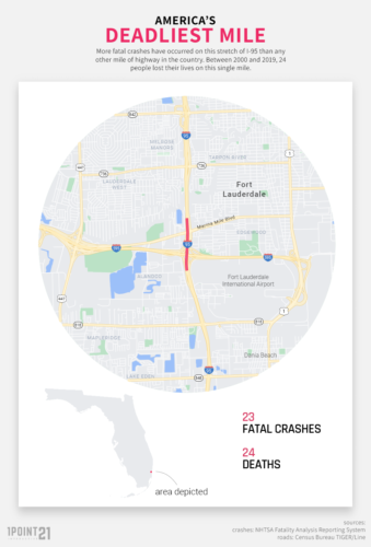
This section of Interstate 95, along with its complex interchanges with I-595 and Marina Mile Boulevard (also known as State Road 84), has been known as the region’s deadliest crossroads for decades. Despite safety warnings, many motorists continue to exit onto Marina Mile Boulevard at high speeds but find themselves unprepared to handle the ramp’s sharp 90-degree turn that lies ahead. The state has also planned to add speed warning signs with flashing beacons, speed limit feedback signs, and speed limit pavement messages within the next few years, as part of the interstate’s improvement project.
The Deadliest 10-Mile Stretches of Highway in the U.S.
We investigated the entire primary U.S. road system to find the deadliest 10-mile segment in each state. We found that all ten of the deadliest highway stretches were in either Texas or Florida – seven were concentrated in Houston and Dallas, Texas, and three in South Florida. During the study period, more than one thousand people lost their lives on these 10 stretches of road.
Dallas was home to five of the deadliest stretches – more than any other city. All five stretches of road are major regional thoroughfares and are some of the most congested highways in Texas. They are heavily used for daily commutes during rush hour traffic.
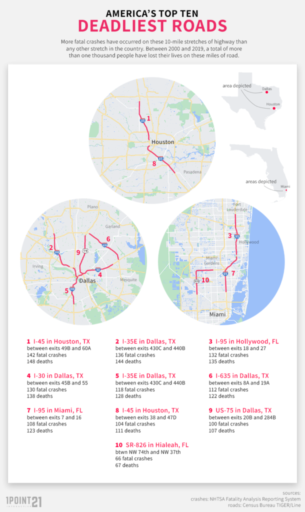
The deadliest stretch of road in the entire United States can be found in Houston, Texas. This section of I-45 runs right through Houston, Texas between exits 49B to 60A. On average, there were 7.7 fatal crashes on that 10-mile stretch every year. The worst year was 2006, with 15 crashes.
The North Houston Highway Improvement Project has been in the works since 2002, with plans of widening and rerouting parts of I-45. However, it was put on hold as of October 2021.
Unsurprisingly, the deadliest mile mentioned above is part of a larger stretch that we found to be the third deadliest in the country. As it turns out, it is just part of a larger stretch of I-95, which is equally dangerous to motorists. Additionally, the seventh deadliest stretch is immediately south on I-95 and the tenth deadliest stretch is just a few miles away, on SR-826 in Hialeah.
The Ten Deadliest Highway Areas in the United States
| Rank | Road | Exits | State | Metro | Crashes | Deaths |
|---|---|---|---|---|---|---|
| 1 | I-45 | 49B – 60A | TX | Houston | 142 | 148 |
| 2 | I-35E | 430C-440B | TX | Dallas | 136 | 144 |
| 3 | I-95 | 18-27 | FL | Miami | 132 | 146 |
| 4 | I-30 | 45B – 55 | TX | Dallas | 130 | 138 |
| 5 | I-35E | 420-430B | TX | Dallas | 118 | 128 |
| 6 | I-635 | 8A-19A | TX | Dallas | 112 | 122 |
| 7 | I-95 | 7 – 16 | FL | Miami | 108 | 123 |
| 8 | I-45 | 38-47D | TX | Houston | 104 | 111 |
| 9 | US-75 | 20B-284B | TX | Dallas | 100 | 107 |
| 10 | SR-826 | NW 74th St – NW 37th ave | FL | Miami | 66 | 67 |
[Interactive Map] See the Deadliest Areas on US Highways
List: The Deadliest Highway Stretch by State
| State | Closest Metro Area | Route Name | Exits | Fatal Crashes | Deaths |
|---|---|---|---|---|---|
| TX | Dallas | I-35 | 49B-60A | 142 | 148 |
| FL | Miami | I-95 | 7-16 | 132 | 135 |
| CA | Los Angeles | I-710 | 6A-15 | 108 | 118 |
| LA | New Orleans | I-10 | 231A-241 | 93 | 96 |
| GA | Atlanta | I-20 | 44-53 | 83 | 89 |
| MI | Detroit | I-75 | 52-61 | 79 | 86 |
| RI | Providence | I-95 | 16-29 | 77 | 80 |
| TN | Memphis | I-240 | 21-32 | 74 | 87 |
| IL | Chicago | I-94 | 61B-71B | 70 | 74 |
| WA | Seattle | I-5 | 161-169 | 70 | 73 |
| MO | St. Louis | I-44 | 199-290C | 69 | 72 |
| AL | Birmingham | I-20 | 115-124A | 69 | 71 |
| MD | Washington | I-495 | 4A-13 | 65 | 70 |
| NY | New York | I-87 | 1-14 (Bronx), 1-2 (Westchester) | 63 | 65 |
| IN | Chicago | I-80 | 1- 10 | 62 | 65 |
| AZ | Phoenix | US Hwy 60 | 173-182 | 62 | 64 |
| PA | Philadelphia | I-95 | 19-27 | 61 | 67 |
| NV | Las Vegas | I-15 | 37-46 | 60 | 65 |
| NC | Charlotte | I-85 | 33-43 | 60 | 63 |
| MS | Jackson | I-20 | 92B-100 | 59 | 69 |
| OK | Tulsa | I-44 | 222A-231 | 58 | 59 |
| AR | Little Rock | I-30 | 126-135 | 56 | 59 |
| OH | Columbus | I-70 | 99A-116 | 53 | 59 |
| CO | Denver | I-70 | 273-282 | 53 | 55 |
| NJ | Newark | Garden State Pkwy | 136-145 | 52 | 55 |
| CT | New Haven | I-95 | 40-51 | 49 | 50 |
| DE | Philadelphia | I-95 | 3-8 | 44 | 49 |
| NM | Albuquerque | I-25 | 240-252 | 42 | 53 |
| WV | Hagerstown | I-81 | 8-16W | 41 | 47 |
| KY | Cincinnati | I-71 | 180-189 | 41 | 42 |
| MN | Minneapolis | I-94 | 229-238 | 40 | 45 |
| SC | Columbia | I-26 | 103-113 | 40 | 42 |
| ID | Nampa | I-84 | 28-36 | 38 | 42 |
| MA | Boston | I-93 | 8-17B | 38 | 39 |
| UT | Salt Lake City | I-15 | 300-309 | 37 | 40 |
| NE | Omaha | I-80 | 445-453 | 35 | 36 |
| VA | Virginia Beach | I-64 | 250A-258B | 33 | 41 |
| KS | Kansas City | I-35 | 225-234 | 33 | 34 |
| HI | Honolulu | I-H-1 | 18A-26 | 31 | 31 |
| OR | Portland | I-5 | 298-308 | 30 | 30 |
| MT | Billings | I-90 | 443-450 | 28 | 31 |
| IA | Des Moines | I-35 | 131-141 | 27 | 29 |
| WY | Laramie | I-80 | 311-323 | 26 | 33 |
| WI | Milwaukee | I-43 | 77-314 | 24 | 24 |
| NH | Nashua | Frederick E Everett Tpke | 5-12 | 22 | 22 |
| AK | Anchorage | State Hwy 1 | N Eagle River-Eklutna | 20 | 22 |
| SD | Rapid City | I-90 | 37-46 | 17 | 20 |
| ME | Kennebunk | I-95 | 19-25 | 15 | 17 |
| VT | Hanover | I-91 | 9-10B | 12 | 13 |
| ND | Fargo | I-94 | 331-343 | 9 | 9 |
Anatomy of a Deadly Stretch
The highway segments with the most fatal crashes are overwhelmingly located within urban areas and are most likely to contain interchanges.
An interchange is an intersection between two primary roadways. Across the entire primary roadway system, there is approximately one interchange every 11.5 miles. Our deadliest 10-mile stretches each contain an average of 1.16 interchanges – 33 percent more than expected.
84 percent of the segments we identified were located partially or fully within the largest metropolitan area in the state. Only three segments, in North Dakota and Vermont, are located fully outside a metro area – though within three miles of it.
Below we include detail on each state’s deadliest highway stretch, grouped by geographic region.
The Western United States
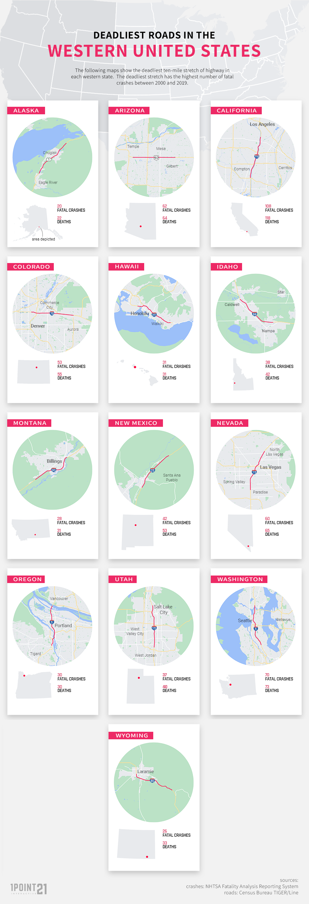
In the western region, the deadliest ten-mile stretch by the total number of fatal crashes was found in California (108).
The Midwest Region
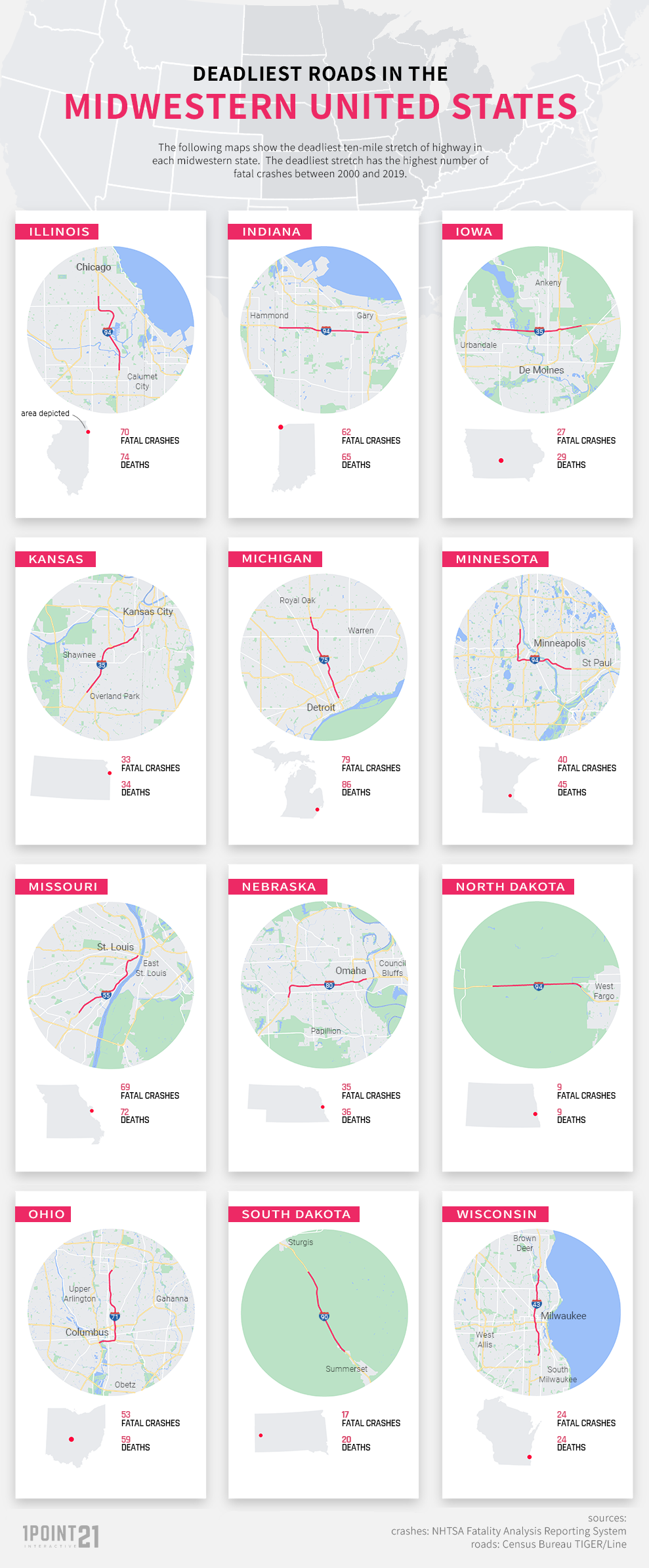
In the midwest, the deadliest ten-mile stretch when ranking by the total number of fatal crashes was found in Michigan (79), closely followed by Illinois (70) and Missouri (69).
The Northeast Region
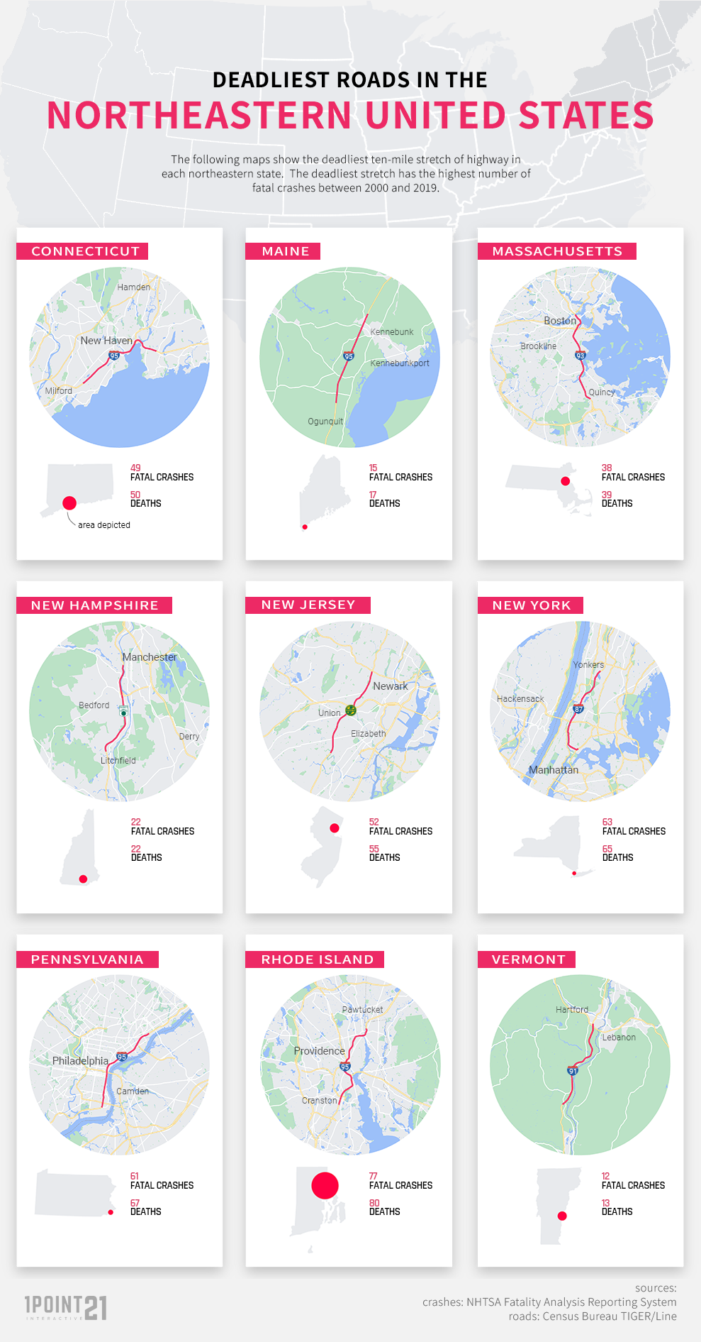
In the northeastern region, Rhode Island had the deadliest ten-mile stretch of highway by the number of total fatal crashes (77).
The Southern Region
In the southern region, the deadliest ten-mile stretch of highway by the total number of fatal crashes was located in Texas (136), closely followed by Florida (132).

Takeaways and Data Sources
While car accidents can occur anywhere or at any time, we can see from this study that there are stretches of road that may warrant extra care and caution on the part of the driver. Many are located in Florida and Texas, in urban areas, and contain interchanges.
With this in mind, drive slower on these deadly stretches of road, drive without distraction, and drive without drug or alcohol impairment. On America’s deadliest stretches of road, a little extra speed can make the difference between life and death, and losing control of your wheel. Slowing down and adjusting to the speed limit, especially while exiting a highway and entering a sharp turn in an exit ramp, can save lives – yours and the drivers around you. Driving slower and more cautiously allows you increased reaction time. It enables you to drive more defensively and protect yourself from other drivers.
This study is based on 2000-2019 fatal crash data from the National Highway Traffic Safety Administration (NHTSA). We only looked at crashes that occurred on a primary road. Primary roads are limited-access highways that connect to other roads only at interchanges and not at at-grade intersections.
If you would like to republish any of the data, images, or findings included, please provide credit by linking to this page.